A county assessor’s office compiles information on the value of parcels of property in a county and the owners of the properties, for purposes of computing property tax payments.
Individual pieces of property are identified by assessor’s parcel numbers and parcel maps.
Parcel Maps
A county assessor’s office keeps a set of maps to identify the location of every parcel of land in a county. The maps are usually accessible either on computer terminals using geographic information system software or in old bound volumes.
If you don’t know the specific address of a piece of property, such as a vacant lot, you can locate the property on a parcel map, and from that determine its address or its assessor’s parcel number.
You then use the address or parcel number to find the assessed value and owner of the property.
Map Books
At the assessor’s office there are maps that divide the county into geographic areas, each of which corresponds to a large bound book, called a map book.
Use the maps to find the map book for the area within which the property you are researching is located.
At the beginning of each map book will be a map that shows the various blocks (like city blocks) within the geographic area the map book covers.
Go to the page for the block that has the property you’re researching.
On the block page you’ll find a map that shows all the individual lots or parcels of property on that block.
Each lot will show its street address or its assessor’s parcel number.
You then can use the assessor’s parcel number index or address index to check for ownership and assessed value of the parcel.
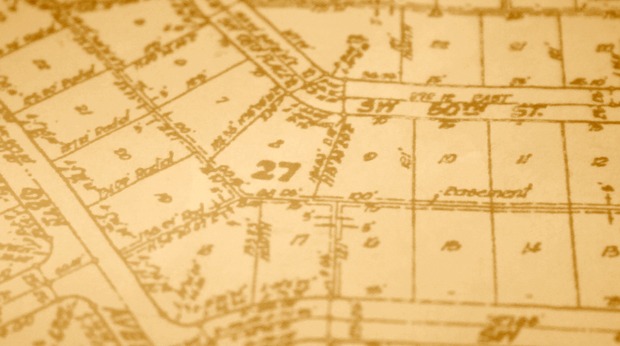
Sample Block and Parcel Map
To see what block and parcel maps look like, go to the Alameda County Assessor’s Office online database for
Property Assessment Information
Type a street address into the search boxes, such as:
2180 Milvia Street, Berkeley
(which is the address for Berkeley City Hall)
At the new page, click on the Map link to get a pdf file of the block and parcel map for this address.
Geographic Information Systems
Some counties are using Geographic Information System software to let you search for the parcel number or address of a property using computer generated maps. These maps are similar to the map book, block and lot/parcel maps of old.
One example of a GIS map is at the Contra Costa County Assessor’s Office:
CCMAP – Contra Costa County GIS Resource
At that page select the zoom tool (the magnifying glass icon with a + on it) above the map and then click anywhere on the map to zoom in. Continue clicking until you see a number displayed for a parcel of property.
This is the street address for that property. You now can click on the select tool (just to the right of the zoom tools) and then click on the street address number to display information about the property to the right, such as the assessor parcel number for the property.
Address Search
Each county assessor’s office has a computer terminal with an alphabetical index by street name and address of all property in that county.
You use this address index to get the assessor’s parcel number for an address, which is a unique identifying number the assessor assigns to each piece of property in a county.
You then can look up the assessor’s parcel number to find out who owns the property and its assessed value (note: you’ll have to go to the assessor’s office in person to find the name of the owner. You cannot find ownership information online).
Sample Address Search
To search an address to get its assessor’s parcel number, go to the Alameda County Assessor’s Office online database for
Property Assessment Information
Type a street address into the search boxes, such as:
2180 Milvia Street, Berkeley
(which is the address for Berkeley City Hall)
At the new page the assessor’s parcel number is listed at the top:
57-2021-1
Assessor’s Parcel Number Search
An assessor’s parcel number is a unique number that a county assessor’s office assigns to each parcel of property in a county (some counties such as San Francisco refer to this as a block and lot number).
Each assessor’s office has a computer terminal with a numerical index by parcel number for looking up detailed information on a piece of property.
The listing for each parcel should include the:
- street address
- name of the owner
- mailing address for the owner (which may be different from the address of the parcel of property)
- assessed value of the property
Note: you’ll have to go to the assessor’s office in person to find the name of the owner. You cannot find ownership information online.
Often a deed number also will be listed, which is a reference to a property deed filed with the county recorder’s office when the current owner purchased the property.
Sample Parcel Number Search
To search an assessor’s parcel number, go to the Contra Costa County Assessor’s Office online map for addresses and parcel numbers
On the right click on the link for Locate parcel by APN
Type a parcel number into the APN search box, such as:
150181050
At the new page click on Default Report at the top right to see the street address for this parcel:
100 Gregory Lane, Pleasant Hill
(which is the address for the Pleasant Hill City Hall)
The assessed value of this property is also listed lower down on the page, and a parcel map for the property is to the right.
Property Transfer List
Assessor’s offices keep an index by parcel number or address that shows if anyone bought or sold the property within the past two years.
This index – called a Property Transfer List or sometimes a Property History Index – lists the:
- names of the buyer and seller
- date of the sale
- amount paid for the property (which might be listed as a documentary transfer tax that can be used to compute the sales price)
- recorder’s office document number for the deed that was recorded when the property was sold
The recorder’s office document number for the property deed can be especially helpful as a starting point at the recorder’s office for doing more detailed research on the history of a piece of property.
California law requires that an assessor’s property transfer list show ownership changes going back two years, but some assessor’s office lists will go back more years.
Note: some assessor offices charge for access to the property transfer lists, which are updated periodically.
Name/Owner Index
Each assessor’s office has on computer terminal with an alphabetical index of the names of people, companies and organizations that own property in each county.
At some assessor’s offices the name index will list for each owner the street address and assessed value of each piece of property they own, along with the assessor’s parcel number for each property.
At other assessor’s offices the index only lists for each owner the assessor’s parcel number of each piece of property they own.
In the latter case, to get the actual address and assessed value and other information on the property, copy down the parcel number and then look up that number on the Assessor’s Parcel Number index.
Assessed Value Caution
The assessed value of a property is supposed to be what the assessor’s office determines is its fair market value – that is, what it could be sold for on the open market.
But because of a state property tax reform act passed by voters in 1978 in California, the assessed value of a piece of property may have little to do with its current actual market value.
The tax reform act – called Proposition 13 or the Jarvis Initiative – placed a 2 percent cap on how much the assessed value of a piece of property could be increased each year, as long as the property was not sold.
Thus a piece of property that has been owned by the same person for many years may be worth far more than the assessed value, because the value of property in California increased much more in past years than the 2 percent annual cap.
If a property is sold, the assessor’s office will do a new assessment of the value of the property that reflects its sales price and hence its actual market value. Thus the more recently a property has been sold, the more likely that its assessed value is close to its real market value.
This also means that two nearly identical properties next to each other may have wildly different assessed values, because one has been owned by the same person for a long time (and thus was subject to the 2 percent annual cap) while the other was recently purchased (and thus has been re-assessed based on the recent sales price).
My best advice is to avoid using assessed values as a measurement of how much a property is actually worth.
Ownership Caution
In California, a county assessor’s office updates the property assessment rolls listing the value and ownership of each property once a year. The information is posted publicly on July 1.
An assessor’s office also will then update its records when a property is sold to reflect the new assessed value and change of ownership.
But there may be a lag time before this information is entered into the publicly accessible database on property ownership. So check with the assessor’s office to determine how up to date the ownership records are.
To verify the current owner of a piece of property you should check the county recorder’s office where property transactions are recorded daily.
The recorder’s office has an index of property related transactions organized alphabetically by the names of the people or companies involved in the transactions, such as the names of the buyer and seller of a piece of property.
Thus you can take the name of a property owner listed at the assessor’s office and check that name at the recorder’s office to see if a property deed has been filed showing the property was recently sold to someone else.
Assessor’s Office Records Online
Many assessor’s offices are putting their indexes of property ownership records online.
But in many cases you can’t find ownership information online because of privacy concerns. Instead you’ll only get basic information like the assessed value of a piece of property, and you’ll have to go to the assessor’s office in person to look up the owner of the property.
One Web site that tracks assessor’s offices that have put their indexes online is:
A private real estate research and information company, NETR has a map of the United States on its home page you can click on to bring up a list of all the county agencies in a particular state that handle property sales and ownership. These include assessor’s offices.
Agencies that have an index of their records available online are noted with a Go to Data Online link.
California Assessor’s Offices
This state government page has links to the websites for the 58 county assessor’s offices in California.
San Francisco Bay Area Assessor’s Office Records Online
Assessor’s offices in the San Francisco Bay Area have online databases for looking up assessed values and other information on properties (but not the names of property owners). They include:
Contra Costa County – click on the View Your Tax Bill link
Contra Costa County – online parcel map
San Francisco County – property information map
About this Tutorial
This tutorial was originally written by Paul Grabowicz for students in his Computer Assisted Reporting class, and later modified for public use.
Republishing Policy
This content may not be republished in print or digital form without express written permission from Berkeley Advanced Media Institute. Please see our Content Redistribution Policy.
© 2020 The Regents of the University of California